Interactive Historic Map
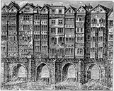
Bristol Bridge

Bristol began life as a village called 'Brigg stow', meaning the meeting place at the bridge in the old Saxon language. At some point a wooden bridge was built across the river Avon and a village grew up beside it ('Avon' is a Celtic word for 'water'). The original medieval wooden structure was rebuilt in stone between 1763-68. A riot occurred in 1793 in protest at the high tolls. An 'L' was added to the words 'Brigg stow' to evolve to 'Bristol' and the Bristolian dialect often adds 'L' to other words, eg: 'Area-L'.
Cumberland Basin
Man made half tidal basin that operates as a huge lock (close).
Bath Road Bridge
Bath Road Bridge was built in 1885 across the New Cut (close).
Instructions
Click on the arrows to the left and right of the map to navigate, and click on the key marker points on the harbour for further information.
You can view the same map and markers in modern times using our Google Map.


